

Cities today have connected sensors, geospatial layers, live transit feeds, climate models, and in many cases, functioning digital twins representing years of investment. The foundation is no longer the limiting factor. The decision is.
The tools available to planners have never been more sophisticated. And yet the process of arriving at a confident, coordinated decision still takes far longer than it should.
What Leading Cities Have Built?
Several cities have made serious investments in digital twin infrastructure, and the results are instructive.
Dublin built its city-scale digital twin to address flooding, congestion, and climate resilience, bringing together engineering models, geospatial data, and operational data in a shared environment for faster, smarter decisions.
Helsinki’s twin serves energy efficiency, flood simulation, and noise modeling across departments, all oriented toward carbon-neutral targets, without rebuilding the platform for each use case.

Singapore went furthest in scale, integrating LIDAR, imagery, and GIS data into a nation-scale twin for planning and infrastructure coordination across multiple government agencies.
Miami created a citywide resilience twin for climate adaptation linking flood models, infrastructure planning, permitting, and investment decisions across departments.
These implementations were built on Bentley’s infrastructure cloud ecosystem, which provides the engineering data environment and interoperability layer that makes multi-agency twins functional.
Bentley’s iTwin platform allows structured engineering data to coexist with geospatial context and live operational streams, and it has become foundational to how serious city-scale twins get built.
The work across these cities represents a genuine leap. But it reveals a consistent gap.
The Pattern Across Every City
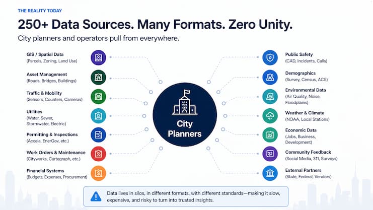
Every city faces the same challenge: critical data is everywhere, but it is scattered across disconnected systems. Live operational feeds, bus and mobility data, climate information, infrastructure systems, and other municipal datasets often remain trapped in silos, making it difficult to understand what is happening across the city as a whole.
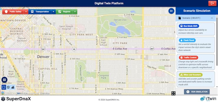
The missing layer is a unifying platform that connects these streams, brings them together visually, and gives cities the ability to run scenarios on top of that data. That means testing what happens if traffic patterns shift, weather worsens, a transit line goes down, or an emergency unfolds-so cities can simulate outcomes, anticipate impacts, and act faster with one coherent view of reality.
Where Geospatial Context Fits In
The most effective city twins share one characteristic: simulations grounded in real geography. When a stormwater model runs inside a geospatial environment that reflects actual basin boundaries, pipe diameters, and land use, the output is immediately interpretable rather than abstract.
The roadmap developing at Cesium, following its integration with Bentley Systems, is building exactly that foundation.
Key capabilities moving toward production include:
- Time-dynamic 3D Tiles, which update a single geospatial dataset incrementally as conditions change rather than requiring a full rebuild
- Volumetric voxel data for continuous representation of subsurface, climate, and environmental analysis
- Composable tiling pipelines accepting inputs from Revit, MicroStation, and other AEC tools into a unified geospatial layer
- iTwin Platform APIs through Cesium, bringing Bentley’s engineering infrastructure directly into geospatial applications
The Layer That’s Still Missing
Most cities have the data and the models. What they lack is the layer that connects them into actual decisions. SuperDNA 3D Lab is building that.
- Scenario orchestration runs multiple what-if simulations simultaneously across existing data sources without rebuilding pipelines each time
- Multi-model execution accepts discrete event, agent-based, and physics-based engines side by side in one environment
- Cross-department outputs give a planner, an engineer, and a finance lead results structured for their role from the same run
- Continuous simulation keeps scenarios live and updatable as conditions change, replacing one-off studies with an ongoing capability
- Decision traceability means every output carries governance-backed KPIs so results can be acted on, not just reviewed
The goal is to compress the time between a question and a decision from days to minutes.
“Cities stop seeing what is happening, said SuperDNA 3D Lab CTO Mike Festa. “They start testing what could.”
 Phil LaMartina is National Sales Director at SuperDNA 3D Lab, a company that builds scenario intelligence infrastructure for cities and enterprise systems. The platform orchestrates existing simulation engines, IoT data, and engineering models, including Bentley’s iTwin, to generate decision-ready outputs across departments.
Header image credit: Andrei Carina on Unsplash