

When most people think of digital twins, they picture high-tech dashboards inside the offices of massive metropolitan governments – New York, Singapore, Rotterdam. The assumption is that this technology belongs to cities with deep pockets and dedicated data science teams.
Rory Linehan thinks that assumption is exactly the problem.
Linehan, Director of Infrastructure Policy Advancement at Bentley Systems, joined host Mike Festa on the latest episode of The Future Of (video below). Together, the two explore one of the most underappreciated opportunities in the spatial computing world: using digital twin technology to help mid-sized and small-sized cities make smarter, more resilient infrastructure decisions – and do it in ways that are accessible, affordable, and genuinely transformative.
It’s a conversation that moves from a North Carolina flood zone to a hydroelectric dam in Ohio, from drone scanning to community engagement, and from urban planning theory to real-world results. And at its core, it’s about democratizing access to some of the most powerful infrastructure tools on the planet.
The Problem No One Is Solving for the Right Cities
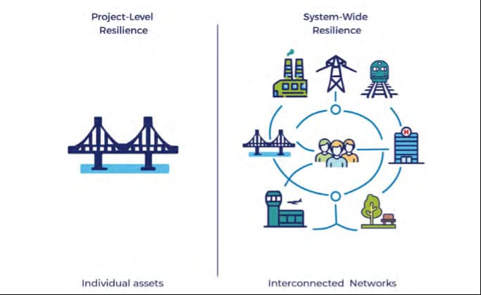
Linehan’s work at Bentley is anchored by a white paper called Built to Endure, developed in collaboration with Duke University, the American Society of Civil Engineers, Microsoft, and AECOM. The project’s focus is pointed and purposeful: how can mid to small-sized US cities use technology to make more resilient infrastructure decisions?
“When you think of the cities doing technology well, you think of New York, Singapore, Rotterdam, London,” Linehan notes. “These are wealthy, well-resourced places. But mid to small-sized cities often get completely overlooked.”
That’s beginning to change. Advances in AI, cloud computing, processing power, and visualization, along with the plummeting cost of these tools, mean that cities that previously couldn’t access enterprise-grade infrastructure modeling now can. The barriers that once made digital twins the exclusive domain of major metros are coming down fast.
The paper outlines eight specific examples of how this is already playing out. One of the most compelling brought Bentley to North Carolina, where conversations with Durham and Chapel Hill both bordering Duke University quickly sparked a much larger ambition.
From White Paper to Digital Twin: The North Carolina Initiative
When Bentley launched Built to Endure in February at an event in Durham, both city mayors were immediately interested. So was the local congresswoman. The enthusiasm wasn’t ceremonial; these communities face real, recurring infrastructure challenges, and they were hungry for tools to help them plan ahead.
That momentum has since grown into a proposal for a cross-city digital twin spanning Durham and Chapel Hill, with support sought through Google’s “AI for Good” grant program, a funding initiative focused on helping municipal governments leverage AI for environmentally and socially responsible decision-making.
For Mike Festa, whose company SuperDNA 3D Lab has been developing a platform called SuperSim described as “SimCity for the real world,” the collaboration represents the convergence of two trends he’s watched build for years: the rise of infrastructure-scale digital twins, and the growing demand from cities for tools that are visual, accessible, and shareable.
Seeing Is Believing: The Case for High-Fidelity Visualization
When discussing this, Linehan describes a straightforward scenario in Chapel Hill: a downtown area near a Trader Joe’s that floods regularly, shutting down businesses for extended periods and costing the community in lost productivity and heartache.
“What if I’m sitting on the planning commission and I can see in fidelity exactly what it’s going to look like if I put a culvert in, or a levee, or do some nature-based infrastructure further down the stream?” he asks. “If I can show that in real-world fidelity, not a spreadsheet, not figures, not a detailed presentation, I’m more likely to make the investment. And so is the state. And so is a federal grant program.”
The argument is simple and powerful: visualization changes the math on decision-making. When stakeholders can actually see what a project does to their neighborhood, their street, their community, the conversation shifts from abstract policy to tangible choice. Drone scanning adds another layer, enabling high-resolution captures of specific areas that can be updated quickly and layered into models with a precision that satellite imagery, often years out of date, simply can’t match.
Linehan cited Wellington, New Zealand as a case study from Built to Endure. The city built a citywide digital twin primarily as a community engagement tool letting citizens visualize not just planned infrastructure projects, but the real-world impact of a magnitude 6, 7, or 8 earthquake on their neighborhoods, and the creeping effects of sea level rise on a coastal city. The result was a more informed, more engaged public that understood why investments were being made rather than feeling like decisions were being imposed on them.
Infrastructure, Climate, and the 80 Percent Problem
Infrastructure is responsible for approximately 80 percent of all greenhouse gas emissions globally.
That number makes the stakes of every infrastructure decision where to build, how to build, what to maintain, what to let go dramatically higher than they might otherwise appear. Getting infrastructure right isn’t just a matter of municipal efficiency or fiscal responsibility. It’s a climate imperative.
“We really have to get our infrastructure right to have a shot at keeping the climate in a place that is safe and habitable,” Linehan says.
Digital twins won’t solve climate change on their own. But when they’re used to model the impact of nature-based infrastructure, optimize energy assets, extend the life of existing systems rather than demolishing and rebuilding, and help communities visualize climate risk in their own neighborhoods they become part of the solution in a concrete, tangible way.
That, ultimately, is what makes the Built to Endure initiative more than a white paper. It’s a framework for action.
The Path Forward: Progressive, Not All-or-Nothing
One of the most practical takeaways from the episode is Festa’s advice to cities that feel overwhelmed by the scope of what’s possible: don’t try to do everything at once.
“You don’t have to jump all in immediately,” he says. “Maybe you start with a drone scan of a specific area, marry the BIM to real-world topography, and share that with people. Get comments. I think ultimately we’re going to have really smart systems connecting all the data – but you can progressively add digital twin layers as you go.”
This incremental approach lowers the barrier to entry significantly. A small municipality doesn’t need to build a full citywide digital twin on day one. They can start with one project, one neighborhood, one problem and let the capability grow from there.
The tools are ready. The data is accumulating. The technology has crossed the accessibility threshold that once made it the preserve of large, well-funded cities. What’s needed now is the ambition and the imagination to use it.
Final Thoughts: A Cusp Worth Standing On
There’s a word both Linehan and Festa reach for more than once in this episode: cusp.
The combination of accessible visualization tools, AI-powered analytics, drone scanning, browser-based platforms, and growing civic appetite for transparency and participation has created conditions that simply didn’t exist five years ago. Mid and small-sized cities – the ones that own and operate the vast majority of US infrastructure can now access capabilities that were previously out of reach.
The question is whether they’ll seize it. If conversations like this one are any indication, the answer is beginning to look like yes.

Jatinder Kukreja is AR Insider’s Contributing Editor. Based in Amsterdam, he’s AR Insider’s European Dispatch, covering XR innovation and the future of 3D commerce. Jatinder’s insights also flow from his role as founder & CEO of SuperDNA 3D Lab.