
In 2006, I attended a launch event in San Francisco for Microsoft Virtual Earth 3D. The product’s main feature was 3D graphical renderings of U.S. cities, starting with San Francisco. It let you essentially fly around a city, sort of like Google Earth but in three dimensions.
The issue was that it required untenable levels of local memory and processing. For most people, it stalled out in buffering and crashed browsers. Since then, Moore’s Law has pushed the concept closer to reality for most folks, but immersive 3D mapping is still an unfulfilled promise.
In fairness, Google Earth offers 3D features. And Google Earth VR, lets users fly around cities in strikingly immersive ways. But that’s a non-starter for anyone outside of the few million people that own VR hardware (much less the compatible HTC and Oculus hardware).
There are also AR-related efforts to capture spatial maps of various locales. This is more about machine-readable data for AR cloud systems to understand surroundings and overlay content accordingly. But these efforts could also contribute to immersive human-readable 3D maps.
Geospatially Sound
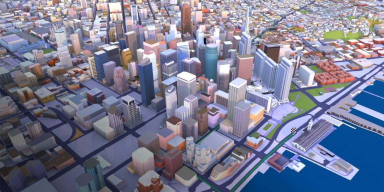
3D mapping’s evolutionary path was recently accelerated with a developer tool from Here Technologies. Here was owned by Nokia before being spun out as its own digital mapping play. It develops advanced 3D mapping technology for self-driving cars among other endpoints.
One of those endpoints is consumer-facing 3D mapping. But as noted, this is a developer platform rather than a fully-baked consumer-ready product. As such, it should provide raw materials for apps to reach the market soon. It offers high-definition 3D models of 75 major cities.
Graphically speaking, Here claims that each structure in a given city is volumetrically and geospatially sound in terms of sub-meter level accuracy in size and elevation. As an additional UX perk, buildings are rendered in their real-world exterior color using the Cesium 3D format.
These maps also include several layers of data, including municipal layers (think: streets, parks) and structural layers (buildings). The latter is where things get interesting for potential use cases and monetization, such as overlaying place databases for business details, store reviews, etc.
In that sense, there could be “peanut butter and chocolate” integrations with location and places datasets from companies like Foursquare. Other potential apps include entertainment, auto-navigation and enterprise-facing tools. But immersive VR experiences could be most compelling.
Force Multiplier
Back to the issue of timing and underlying tech (a gating factor for Microsoft Virtual Earth 3D in 2006), a force multiplier for all of the above may be 5G. As we’ve examined, 5G enables not just faster speeds and low-latency, but its high-frequency signal enables millimeter-level geo-precision.
Practically speaking, any 3D mapping product is doomed if it can’t precisely pinpoint where you’re standing when using it. GPS fails in dense urban areas — one intended venue for Here’s new platform — due to misdirected/bouncing satellite signals. But 5G could resolve that.
Another technology that could support immersive 3D maps is, again, the construction of the AR Cloud. With more tech giants building spatial maps to power AR experiences, greater levels of data are created that can contribute to the construction of digital twins of major cities.
That includes Google’s internet of places, Apple’s related moves, Facebook’s Project Aria, Snap Local Lenses and Niantic’s work to crowdsource spatial mapping to Pokemon Go players. Again, these are more about point clouds that enable better AR….but could have other outcomes.
Meanwhile, Here’s developer tool engenders a broader set of user experiences that go beyond AR & VR. Because it’s a developer tool, we won’t get to see those outcomes yet. But we can look forward to lots of third-party creativity to build compelling 3D city apps in the coming months.